Government
Extends River Basin Management Scheme
The River Basin Management Scheme has been extended
through the 16th Finance Commission period (2026–27 to 2030–31), reflecting an
emphasis on the integrated and sustainable management of India's water
resources—particularly at the basin level.
What is the River Basin Management (RBM)
Scheme?
- ¨ The RBM Scheme is a Central Sector Initiative administered by the Ministry of Jal Shakti (Department of Water Resources, River Development, and Ganga Rejuvenation).
- Its primary objective is to ensure the integrated planning, sustainable utilization, and conservation of surface water and groundwater at the river basin level.
- Under this scheme, rather than viewing water resources in isolation, the entire river basin—comprising rivers, their tributaries, lakes, and groundwater—is treated as an integrated and interconnected system.
- Institutional Framework: The River Basin Management (RBM) Scheme consists of two key components: the Brahmaputra Board, and the Integrated Water Resources Development Scheme (IWRDS), which is implemented through the Central Water Commission (CWC) and the National Water Development Agency (NWDA).
- Brahmaputra Board: This body focuses on river basin planning, flood control, erosion management, drainage development, and the sustainable management of water resources within the North-Eastern region.
- Central Water Commission (CWC): It undertakes surveys and investigations for water resource projects in remote areas, in addition to preparing Detailed Project Reports (DPRs).
- National Water Development Agency (NWDA): This agency handles water planning atthe national level, specifically focusing on the preparation of feasibility reports for the Inter-Linking of Rivers (ILR) Programme.
- Geographical Priority: The scheme strategically targets water-rich yet underdeveloped regions that are of critical importance from the perspectives of national security, water security, trans-boundary management, flood control, and ecological stability.
- The key targeted areas include the Brahmaputra, Barak, Teesta, and Indus basins, with the North-Eastern states, Jammu and Kashmir, and Ladakh accorded high priority.
Key Objectives
- ¨ Flood and Erosion Management: Implementing physical conservation measures, such as protecting Majuli Island in Assam from strong river currents.
- Project Development: Preparing Detailed Project Reports (DPRs) to expand irrigation capacity and to harness the hydroelectric power generation potential of Himalayan rivers.
- Technology Integration: Utilizing modern mapping and surveying tools—such as Geographic Information Systems (GIS), LiDAR, and drone surveys—to ensure high precision in topographical and hydrological planning.
- Community Integration: Promoting indigenous practices, such as spring-shed management, among tribal and rural communities in mountainous regions.
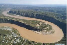
River Basins
- ¨ A river basin is a terrestrial area drained by a river and its tributaries. Its key components include tributaries (smaller streams that flow into the main river), confluences (points where rivers meet), watersheds (high-elevation boundaries separating different basins), origins (the starting source of a river), and mouths (the points where rivers discharge into a sea, lake, or ocean).
- In India, the river basin is considered the fundamental hydrological unit for the planning and development of water resources.
- India's River Basins: India's drainage system is classified into 20 river basin groups, comprising 12 major river basins and 8 composite river basins.
- The major river basins—defined as those with a drainage area exceeding 20,000 square kilometers—include the Indus, Ganga–Brahmaputra–Meghna, Godavari, Krishna, Cauvery, Mahanadi, Pennar, Brahmani–Baitarani, Sabarmati, Mahi, Narmada, and Tapi.
- The Ganga–Brahmaputra–Meghna basin is the largest of these, boasting a catchment area of approximately 1.1 million square kilometers, which accounts for over 43% of the total catchment area of all major river basins.
- The catchment area of medium river basins ranges between 2,000 and 20,000 square kilometers, whereas small basins cover an area of less than 2,000 square kilometers.
- Eight composite basins have been formed by aggregating smaller groups of rivers, such as the Subarnarekha group; the east-flowing rivers situated between the major basins; the west-flowing rivers of Kutch and Saurashtra (including the Luni); the coastal rivers extending from the Tapi to Kanyakumari; and the inland drainage areas of Rajasthan.
- Notably, all major river basins and several medium basins are inter-state in nature, collectively spanning approximately 81% of India's geographical area.