Extreme Weather Events in India:
Challenges, Impacts, and Management Strategies
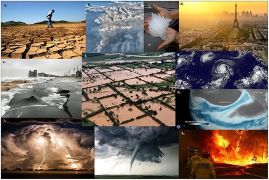
India is a country characterized by immense
geographical and climatic diversity, where extreme weather events—such as
floods, cyclones, and heatwaves—occur frequently. Driven by the impacts of
climate change, both the intensity and frequency of these disasters are on the
rise, exerting a profound impact on human lives, agriculture, infrastructure,
and the economy. In such circumstances, effective disaster management and the
timely issuance of warnings become absolutely imperative.
Multi-Hazard Early Warning Decision
Support System
¨
This is a digital
platform that automates critical weather forecasting processes, as well as the
decision-making procedures related to providing forecasts and warning services
to the general public, governmental and non-governmental agencies, and specific
stakeholders.
¨
It has been developed by
the India Meteorological Department (IMD) utilizing open-source technology and
in-house expertise.
¨
Launched in January 2024
under 'Mission Mausam' (Mission Weather), this platform integrates data from
satellites, radars, and other observational sources with advanced forecasting
tools. It employs Geographic Information System (GIS) maps to facilitate the
efficient collection, analysis, and dissemination of weather data.
¨ It provides real-time,
impact-based, multi-hazard forecasts across the entire country. By translating
complex meteorological data into actionable warnings, it empowers both
decision-makers and local communities.
¨
The system also
incorporates a public-facing platform known as 'Mausamgram,' which delivers
hyper-local weather forecasts upon the entry of a location name or PIN code.
¨ It reflects the
Government of India's vision of a "Weather-Ready and Climate-Smart
Nation" and embodies the philosophy of "Har Har Mausam, Har Ghar
Mausam" (Weather for Every Season, Weather for Every Household).
Key Features of MHEW-DSS
¨ Automated Weather Data
Processing: Over 90% of the processes involved in meteorological data
collection, quality checks, and integration have now been automated.
¨ Enhanced Utilization of
Forecasting Models:** Over 95% of the inputs from statistical weather
forecasting models are now being utilized in the forecasting process.
¨
Extended Forecast
Duration: The time horizon for weather forecasts has been extended from 5 days
to 7 days.
¨
Accelerated Forecast
Preparation: The time required to generate a forecast has been reduced from 6
hours to approximately 3 hours.
¨
Cost Savings and
Self-Reliance: This system has resulted in cost savings of approximately ₹250
crore and has eliminated dependence on foreign vendors.
¨
Reduction in Evacuation
Costs: Thanks to improved early warning systems, evacuation costs have
decreased to one-third of their previous levels between 1999 and 2024. This
achievement has been made possible by the IMD issuing accurate forecasts—3 to 5
days in advance—regarding the precise landfall location of cyclones.
Operational Structure of MHEW-DSS
¨ Weather Analysis and
Forecasting Enabling System (WAFES):** This system assists forecasters in
analyzing data, generating charts, and visually monitoring weather conditions
through GIS-based maps.
¨
Utilizing a GIS-enabled
platform, it integrates color-coded alerts for various types of disasters.
¨ To ensure timely action
and disaster preparedness, it disseminates these warnings through digital
channels such as SMS, email, Application Programming Interfaces (APIs), mobile
applications (e.g., Mausam), the Common Alerting Protocol (CAP), and graphical
bulletins.


 Programme.jpg)