Multi-Hazard Early Warning System: India's
Integrated Initiative in Disaster Management
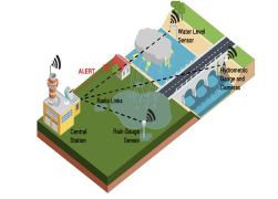
In a country like India, characterized by its vastness
and diverse geographical conditions, extreme weather events—such as floods,
cyclones, and heatwaves—occur frequently. Driven by the impacts of climate
change, both the frequency and intensity of these disasters are on the rise,
thereby significantly heightening the country's vulnerability. In such a
scenario, the existence of an effective and timely Early Warning System becomes
absolutely imperative.
Multi-Hazard Early Warning Decision
Support System (MHEW-DSS)
¨ It is a digital platform
that automates the decision-making on critical weather forecasting processes
and forecast and warning services to the public, government, and non-government
agencies, as well as specific stakeholders.
¨ It has been developed by
the India Meteorological Department using open-source technology and in-house
expertise.
¨ Launched under Mission
Mausam in January 2024, it combines satellite, radar, and other observational
data with advanced forecasting tools and utilises Geographic Information System
(GIS) maps for efficient collection, analysis, and dissemination of weather
data.
¨ It delivers real-time,
impact-based multi-hazard forecasting across India, empowering decision-makers
and communities by translating complex meteorological data into actionable
warnings.
¨ It also includes a public
platform named Mausamgram, which provides hyper-local weather forecasts by
entering the name of the place or the Pincode of the place. It reflects the
Government of India’s vision of a “Weather Ready and Climate Smart Nation” and
embodies the philosophy of “Har Har Mausam, Har Ghar Mausam.
Salient Features of the MHEW-DSS
¨
Automated Weather Data
Processing: Over 90% of weather data collection, quality checks, and
integration are automated.
¨ Better Use of Forecast
Models: More than 95% of numerical weather prediction model inputs are now used
in forecasting.
¨ Longer Forecast Lead
Time: Forecast lead time has increased from 5 days to 7 days.
¨
Faster Forecast
Preparation: The time required to prepare forecasts has reduced by about 3
hours from 6 hours.
¨ Cost Savings and
Self-Reliance: The system has generated around ₹250 crore in cost savings and
eliminated dependence on foreign vendors.
¨ Reduced Evacuation Costs:
Improved early warnings have helped reduce evacuation costs to one-third from
1999 to 2024 due to a reduction in cyclone landfall point forecast error in the
3-5 days ahead forecast issued by IMD.
Operational Architecture of the MHEW-DSS
¨ Weather Analysis and
Forecast Enabling System (WAFES) helps forecasters analyse data, generate
charts, and visualise weather conditions through GIS-based maps.
¨ Using a GIS-enabled
platform, it integrates colour-coded alerts for various hazards and
disseminates them through digital channels like SMS, emails, Application
Programming Interface (API), Mobile App (Mausam), Common Alerting Protocol
(CAP) and graphical bulletins to ensure timely action and disaster preparedness.

 Programme.jpg)